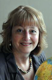
Кристиане ШМУЛЛИУС

ДОЛЖНОСТЬ:
Профессор кафедры дистанционных исследований Земли, университет им. Фридриха Шиллера, Йена, Германия
КОНТАКТЫ:
Lehrstuhl für Fernerkundung, Institut für Geographie, Friedrich-Schiller-Universität Jena
Grietgasse 6, 07743 Jena, Germany
Tel.: +49 (0) 3641 94 88 80
Fax: +49 (0) 3641 94 88 82
E-mail: c.schmullius@uni-jena.de
НАУЧНЫЕ ИНТЕРЕСЫ:
Картографирование почвенно-растительного покрова, структуры и биомассы лесов, дистанционное зондирование лесов.
ЭТАПЫ ПРОФЕССИОНАЛЬНОЙ ДЕЯТЕЛЬНОСТИ:
2004-н.в. - руководитель группы геоинформатики Института микроволновых и радарных исследований Национального аэрокосмического центра Германии (DLR), Оберпфаффенхофен, Германия
2000-н.в. - профессор кафедры дистанционных исследований Земли, университет им. Фридриха Шиллера, Йена, Германия,
ОБРАЗОВАНИЕ:
1991 PhD "Космические исследования", свободный университет Берлина, Германия
1984 географический факультет университета Калифорнии в Санта-Барбаре, США
ОСНОВНЫЕ ПУБЛИКАЦИИ:
- Voltersen M., Berger C., Hese S., Schmullius C. Object-based land cover mapping and comprehensive feature calculation for an automated derivation of urban structure types at block level, Remote Sensing of Environment, 2014, Vol. 154, pp. 192–201.
- Walde I., Hese S., Berger C., Schmullius C. From land cover-graphs to urban structure types, International Journal of Geographical Information Science, 2014, Vol. 28, No. 3, pp. 584–609.
- Berger C., Voltersen M., Eckardt R., Eberle J., Heyer T., Salepci N., Hese S., Schmullius C., Tao J., Auer S., Bamler R., Ewald K., Gartley M., Jacobson J., Buswell A., Du Q., Pacifici F. Multi-modal and multi-temporal data fusion: Outcome of the 2012 GRSS data fusion contest, IEEE Journal of Selected Topics in Applied Earth Observations and Remote Sensing, 2013, Vol. 6, No. 3, pp. 1324–1340.
- Berger C., Voltersen M., Walde I., Hese S., Schmullius C. Robust extraction of urban land cover information from HSR multi-spectral and LiDAR data // IEEE Journal of Selected Topics in Applied Earth Observations and Remote Sensing, 2013, Vol. 6, No. 5, pp. 2196–2211.
- Eckardt R., Berger C., Thiel C., Schmullius C. Removal of optically thick clouds from multi-spectral satellite images using multi-frequency SAR data, Remote Sensing, 2013, Vol. 5, No. 6, pp. 2973–3006.
- Walde I., Hese S., Berger C., Schmullius C. Graph based mapping of urban structure types from high resolution satellite image objects – A case study of the German cities of Rostock and Erfurt, IEEE Geoscience and Remote Sensing Letters, 2013, Vol. 10, No. 4, pp. 932–936.
- Avitabile V., Baccini A., Friedl M.A., Schmullius C. Capabilities and limitations of Landsat and land cover data for aboveground woody biomass estimation of Uganda, Remote Sensing of Environment, 2012, Vol. 117, Р. 366-380.
- Berger C., Voltersen M., Hese S., Walde I., Schmullius C. Using geographic object-based image analysis (GEOBIA) for land cover mapping and settlement density assessment, GEOBIA 2012, Proc. Conf., 7-9 May 2012, Rio de Janeiro, Brazil. P. 503-508.
- Walde I., Hese S., Berger C., Schmullius C. Graph-based urban land use mapping from high resolution satellite images // ISPRS Annals of the Photogrammetry, Remote Sensing and Spatial Information Sciences, I-4. 2012. P. 119–124.
ДОПОЛНИТЕЛЬНЫЕ ОБЛАСТИ ПРОФЕССИОНАЛЬНЫХ ИНТЕРЕСОВ:
Член исполнительного комитета немецкого научного фонда "Future Earth"
Руководитель сенатского комитета национального аэрокосмического центра Германии
Советник консультативного комитета по наукам о Земле Европейского космического агентства
Советник консультативного совета Европейской комиссии по космическим исследованиям
Член редколлегии "Сибирского лесного журнала"

